No weather is ill if the wind is still.
At least that’s what Grandma believed. Wind can be quite welcome: a refreshing breeze off the water on a scorching afternoon, for example. It’ll be a while before we experience that one. This week the wind is not pleasant. It’s generally from the east – at times from the northeast. In April, that is not as favourable of a wind direction.
As I plotted maps and prepared graphics for my weather video earlier this week, I remembered receiving a question about the wind. I found it, but I didn’t keep the full email so I’m not sure who sent it in. Regardless, I feel it’s quite timely, at least the second half of it is.
“Hi Cindy, here's a question for you about wind direction. As a hunter, I'm constantly watching wind direction and have noticed we rarely get an east wind this time of year. What conditions are needed for an east wind in Nova Scotia? Thank you!”
Let’s start with any wind. Wind is caused by air flowing from high pressure to low pressure. The Earth's rotation prevents that flow from being direct but deflects it side to side (right in the Northern Hemisphere and left in the Southern Hemisphere), so wind flows around the high and low-pressure areas.
Getting back to the question: what weather configuration serves up an east wind?
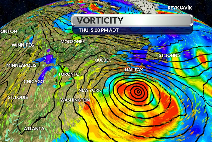
A large-scale east wind across the region would be the result of air flowing out of a high-pressure system north to the north and a counter-clockwise circulation around a large offshore low. The closer the high and low-pressure areas are to each other, the stronger the pressure gradient and the stronger the winds. On weather maps, lines of constant pressure are called isobars.
That’s what we’ve had going on much of the week, but with an interesting twist. Large scale features in the atmosphere became detached from the upper-air flow and created a very unusual weather pattern. Instead of seeing the wet weather move in from the west, it’s backing in from the east. This is known as a retrograde: to move in the opposite direction of what is climatologically typical. In the middle latitudes, pressure systems tend to move generally from the west toward the east, but not this week. An unusual pattern for unusual times!
- Want more weather information? Visit your weather page.
- Have a weather question, photo or drawing to share with Cindy Day? Email [email protected]