The system that led to the weather bomb dropped on eastern Newfoundland Thursday may be somewhat unusual, but is becoming more and more common in the region and will likely increase in frequency, says SaltWire meteorologist Cindy Day.
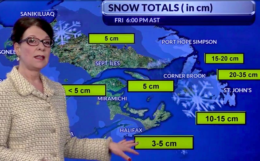
The storm, which began at its predicted time around noon Thursday, was expected to drop 30 or more centimetres of snow on most of the Avalon Peninsula, the Bonavista Peninsula and Bonavista North area before it's done. There's also the added complication of high winds.
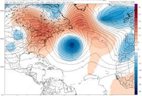
It’s the result of a low-pressure system that stalled north of the island Wednesday long enough for it to fasten itself to another low, a rapidly intensifying system that sped up from the New England coast.
The initial low, finding itself blocked by a high-pressure system situated over Greenland, backtracked towards Newfoundland, where it waited for its partner.
That high-pressure barrier over Greenland can’t be classified as an anomaly; it’s part of a pattern noticed as far back as the 1980s. However, Day says it’s becoming more and more common, because of — as you might have expected — climate change.
“There have been some studies over the past year saying that with our changing climate, with the sea-surface temperatures changing, we’re going to see that blocking occurring even more frequently,” she said.
RELATED
- Weather bomb ready to go off over eastern Newfoundland
- UPDATE: Winter's stern command comes to bear on Newfoundland and Labrador
“That’s something we need to track, but over the next few decades, I think we’re certainly going to see more of that occurring, with a system that stalls there.
“That changes everything, especially for eastern Canada.
This particular system — which led to a winter storm warning — delivered a quick, specifically targeted combination weather punch. The northeast coast, parts of central Newfoundland Northern Peninsula and Labrador coast are also seeing significant snow as a result, but it is the eastern part of the province that will be truly rocked by the winter uppercut.
“It’s really quite compact in terms of the area that’s hardest hit with the combined effect of the strongest wind and snow... and that will be the Avalon and Bonavista peninsulas,” said Day as the storm approached.
“To me, with the way the polar vortex is starting to wobble, the way the jet stream is repositioning, I’d say the second half of winter is going to be quite stormy, with a lot of snow." — Cindy Day
Before this week, most of Newfoundland had been spared what might be termed a normal winter, with little or snow in areas west to east on the island. And it’s been the same in much of the rest of Atlantic Canada, something which has the Halifax-based Day paying particular attention to this storm.
”We’ve been lucky, at least if you’re not a fan of snow,” she said, adding she can’t count herself in that group.
“I like winter with snow, but it’s true people have been talking about this system because of the lack of snow in most areas.”
The snowfall was forecast to stop on the Avalon Friday morning, followed by a clearing trend and even the chance of afternoon sunshine. As the system finally moves off, there will probably be more snow Saturday in the form of squalls, perhaps as a reminder there will be more of the white stuff arriving n the weeks that follow.
Day says despite what has been a tardy appearance by winter, now that it has arrived, it will likely do its best to ensure its presence is known… and that’s in all areas of the province.
“To me, with the way the polar vortex is starting to wobble, the way the jet stream is repositioning, I’d say the second half of winter is going to be quite stormy, with a lot of snow,” she said.
“So, if you have snowshoes or a snow machine you’ve been wanting to use, hang tough, it’s coming to most places, just a little later than what we are used to seeing.”
@Tely_Brendan