I wish I had one.
I wish we all did.
I found one version — though not my own — this weekend.

It was between Adam’s Cove and the resettled community of Bradley’s Cove in Conception Bay North. I’m reasonably sure it hasn’t been seen by anyone else in decades.
Because it wasn’t easy to find.
First, you head for the highest of the high ground right on the water between the two communities. The only trees are a few scruffs of sturdy wind-hedged spruce; most of the ground is covered by hummocked plants better suited to constant wind and to living despite there being almost no soil at all. Mosses, long tendrils of bright green ground juniper, blueberry — the higher up you climb, the less variety there is amongst the vegetation.
It’s mostly the preserve of gulls up there: gulls wheeling, and somewhere, at least one avian predator that likes to bring whole gulls’ eggs, beige and spotted with brown, up from the cliffside nests nearby, poke in a beak-window and eat the contents, leaving a nearly complete shell behind. Sometimes, there’s enough wind for a hollowed-out shell to come skipping towards you across the ground.
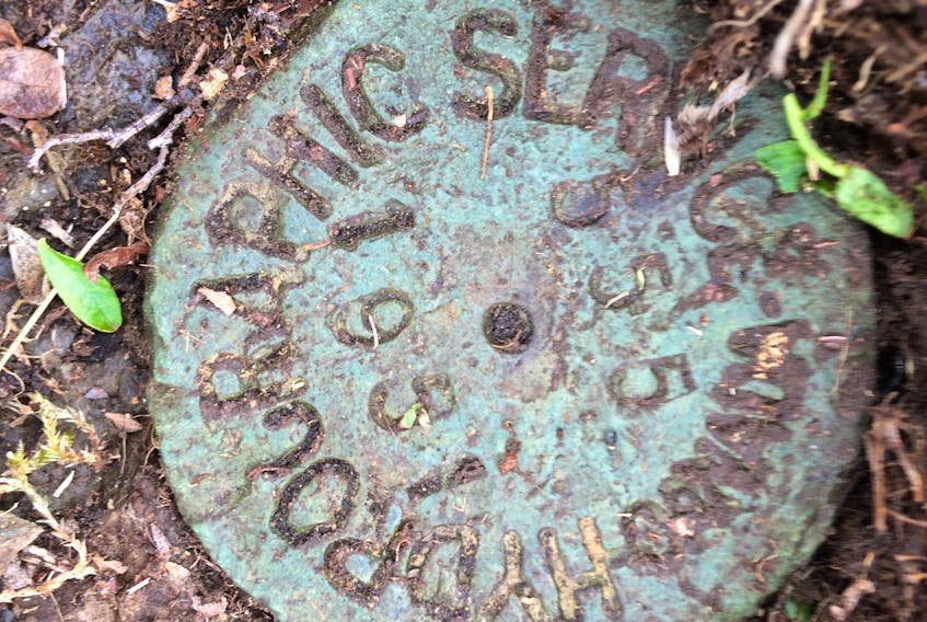
And somewhere up there is the Canadian Hydrographic Service’s waypoint No. 555, a brass disk cemented into place during a survey in 1951, after the CHS took over making ocean charts from the British Royal Navy.
About two inches down through the roots, and there it was: conclusive, irrefutable proof that for this short time, I knew my footing and location precisely.
You wouldn’t know it was there. The most prominent feature at the very top of the windy hill is a broad stone circle surrounding a fire pit: soaked ashes, half-burned logs. A huge panoramic view of the ocean — icebergs at times, breaching whales this week — but first you have to catch your breath.
If you want to know how truly tough ground-creeping cranberries (the ones that Scandinavians call lingonberries) really are, try peeling back their root-mat. They cable themselves down with a hard wooden mesh of stiff roots, strapping their way across bare rock and then garnering their own gardens of trapped peat, leaves and other rudiments of soil. About two inches down through the roots, and there it was: conclusive, irrefutable proof that for this short time, I knew my footing and location precisely.
Would that life were so simple.
I often wonder when any of us get an easy year. When I was a kid, I thought that it would be far simpler to be an adult. As a young adult with kids, I spent a lot of time thinking how life would get simpler when they were grown. This year, after a bruising 12 months of deaths and illness among family, friends and even — horribly — friends’ children, all I can think of is that the anchors we expect to have, that we lean on and depend on, are far more tenuous than we would like to believe.
Marker 555 has been in the ground in that one fixed place for longer than I’ve been alive, with little more change in its world than the cranberries working their way overtop like a slowly closing eye. Blessedly constant.
Russell Wangersky’s column appears in 36 SaltWire newspapers and websites in Atlantic Canada. He can be reached at [email protected] — Twitter: @wangersky.
MORE FROM RUSSELL WANGERSKY