A hike in the ocean water temperature is fueling stronger and longer-lived storms.
Canadian Hurricane Centre's (CHC) Bob Robichaud said the average number of storms is 12, but this year, between 19 to 25 are expected.
"We are already above average this year for storms. But those storms and numbers that I just gave are for essentially storms forming in the overall Atlantic Ocean, and we do not know where they will land," said Robichaud, the warning preparedness meteorologist with CHC.
There is still around 65 per cent of hurricane activity to come, said Robichaud and hurricane season traditionally peaks in September.
"The increase we see in hurricane activity is not necessarily climate change, but the much bigger signals controlling them are first, the warmer water in the Atlantic Ocean. This warmer water varies on a cycle for about 20 to 40 years, so we get into these more frequent hurricane activity periods."
Since 1995, we have been in one of these active cycles, "and we do expect at some point – when nobody knows – a decrease in the warmer water activity, but we are certainly not there yet," he continued.
"The other signal is a lower wind shear (change in wind speed or direction that goes up into the atmosphere) in the tropical Atlantic this year. Hurricanes do not like environments with a lot of wind shear because they break them apart, so this year we have two events combining to result in a highly active hurricane season."
SaltWire meteorologist Cindy Day agreed that the warming of the sea surface temperature by – on average – more than two degrees has given rise to more severe weather.
"Whether these (storm) systems reach Atlantic Canada is defined by where the system sits in the days leading up and the energy travelling into our waters," she said.
"This year, we are already tackling Laura, and Marco has come and gone. The storms' average date to be forming is early, and this seems to be the trend over the past couple of years."
Robichaud explained, "The generic term that we use is a tropical cyclone, now within that, you have a tropical storm where winds are at least 63 kilometres per hour (km/h), if that same storm intensifies and the wind reach 119km/h that's when it gets classed as a hurricane.
"It only gets a name when the storm reaches tropical storm intensity. Suppose it intensifies to a hurricane with winds of 178 km/h; that's when it gets categorized as a 'major hurricane' such as a Category 3, 4 and 5. Laura that impacted Louisiana in the United States, was a 'major hurricane' Category 4."
The term ‘post-tropical’ may prompt people to let their guard down, but post-tropical has nothing to do with the storm's intensity – rather, it’s to do with is the structure of the storm.
Year since Dorian

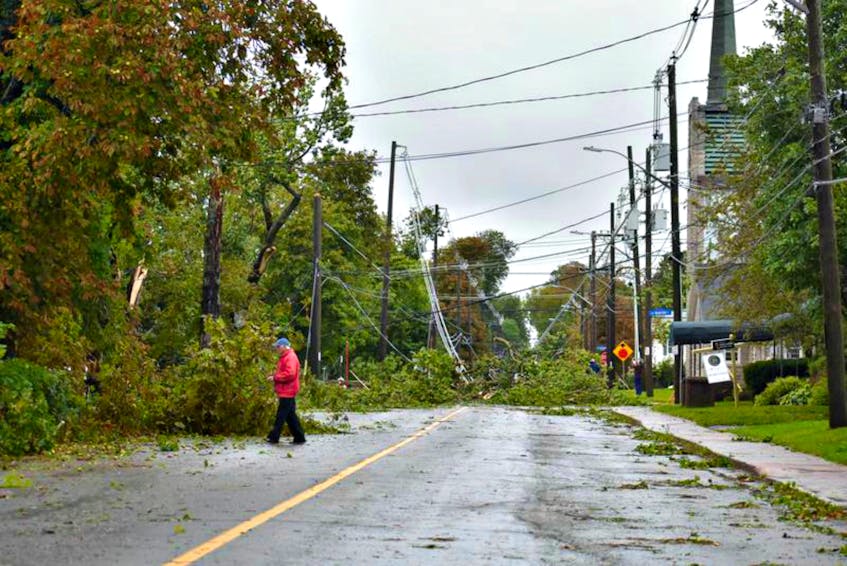
In September 2019, while Dorian was downgraded from a Category 5 hurricane to a post-tropical storm when it slammed Atlantic Canada, it caused $105 million in insured damages across the region.
The Insurance Bureau of Canada (IBC) stated that “70 per cent of this amount is for damage to personal property, 25 per cent is for damage to commercial property, and the remaining amount is for damage to automobiles.”
Dorian was the fourth named storm in the season, revealing how devastating Mother Nature can be.
The Bermuda High (a high-pressure system located over the Atlantic Ocean) can significantly impact the track and strength of a tropical storm, determining where it makes landfall, says Day.
"Its pressure system pushes up, on the Jetstream (a line of cold and warm air), so I would say from mid-July, that Jetstream has been tracking up through Labrador, allowing for some very warm air to funnel across Atlantic Canada.
Day said this northernly Jetstream would likely be a trend as appose to an anomaly if we continue with these warmer than usual (water) surface temperatures.
While it is too soon to predict winter storms, Day acknowledged the East Coast could be looking at powerful late fall storms because of excessive heat.
"The early part of winter could see an increase in powerful storms because of this latent heat building in the ocean's top level.”
As we head towards the peak hurricane season, the key message is to start preparing with a basic emergency kit that will last for at least 72 hours when disaster strikes.
"We must prepare with food that won't spoil, water, batteries, first aid kits, even sooner than we would have been in the past because of social distancing and safety measures with COVID-19," said Day.
Robichaud added that it’s too early to predict what, exactly, the East Coast may see as hurricane season moves forward.
"We could see another storm like Dorian this year, but we might see nothing this year,” he said. “The hard part of predicting the risk involved with these storms is that we can typically get a good feel for the level activity over the Atlantic Basin, but we cannot see where the storm will go."
Almost one year to this day, Dorian became a major hurricane in the Bahamas, and many were lining up last minute to get propane and other essentials.
"You want to get those preparations done before the storm even shows up on the map. Having an extra propane tank at the ready, extra fuel for those with a generator, water, and other provincials on hand, will be beneficial so you can avoid long store lines," said Robichaud.
How we deal with hurricane preparations amid COVID-19 will undoubtedly be different this year.