CHARLOTTETOWN, P.E.I. — UPDATE: Kim Griffin, corporate spokeswoman with Maritime Electric, said Thursday morning that extra crews from Ontario had been called in to help with any damage post-tropical storm Teddy might inflict on P.E.I. That was in advance of the storm.
However, Griffin said those crews have been turned back considering the storm wasn't nearly as bad as originally forecast. She said it's the first time that crews outside of the utility's own had been called in before the storm hit. It's part of Maritime Electric's effort to be more prepared following the devastation of last year's post-tropical storm Dorian.
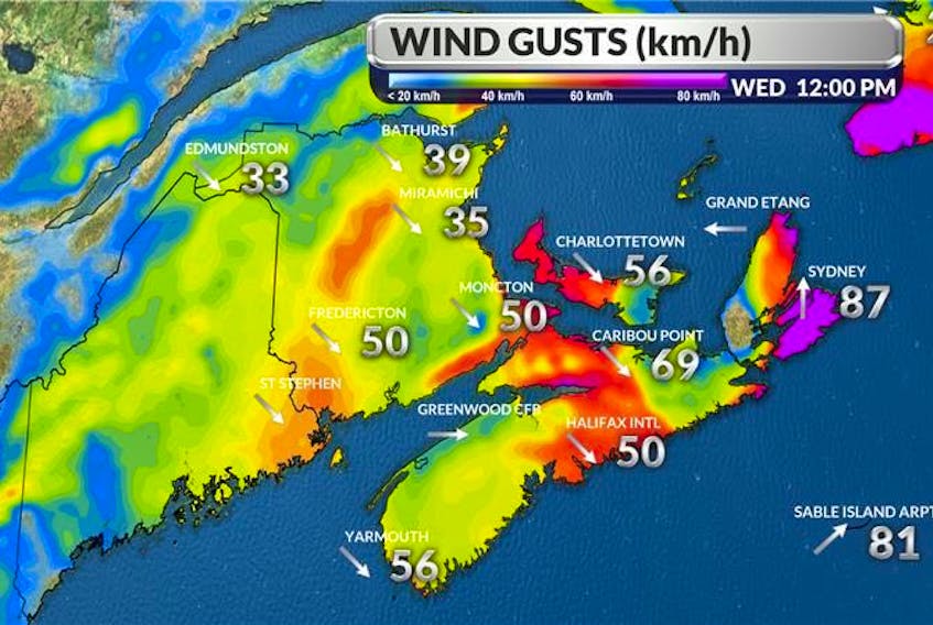
After a rather calm night across Prince Edward Island, winds have been picking up steam today.
Cindy Day, chief meteorologist with the SaltWire Network, held a media briefing this morning to update the situation with hurricane Teddy.
The system made landfall between 8 and 9 a.m. between Sheet Harbour and Port Bickerton in Nova Scotia as a post-tropical storm and is expected to pound the Atlantic provinces for the remainder of the day with strong winds and, in some areas, pounding waves and storm surges.
P.E.I. remains under a tropical storm watch which means that sustained winds could, at times, reach 65 km/h.
However, Day said she expects the Island will see sustained winds around 50 km/h.
Wind gusts, on the other hand, will be stronger.
Day said the province could see gusts as strong as 100 km/h between 2 and 5 p.m. today before diminishing to gusts of 80 km/h out of the northwest, dropping down to gusts of 50 km/h tonight and then 40 to 50 km/h overnight.
Day added that there should be no storm surge issues to worry about for coastal P.E.I.
“The waves will build a little bit but the storm is breaking down,’’ she said.
As for rainfall, between 40 and 50 millimetres had fallen across the province as of 9 a.m. Wednesday morning, although the Bonshaw area saw 60 millimetres. Day expects a further 20 millimetres will fall before everything calms down tonight.