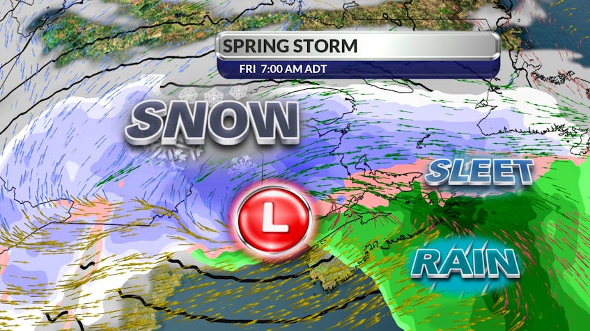
Rain, snow and a lot of wind is set to hit P.E.I. on Good Friday.
SaltWire’s chief meteorologist Cindy Day said Prince County could see more than 15 centimetres of snow in what she calls rapidly intensifying weather.
“The system that is coming in is a good spring storm,’’ Day said on Wednesday. “It is going to be very close . . . to a weather bomb.’’

A weather bomb happens when an area of low pressure outside of the tropics drops its pressure by 24 millibars or more in 24 hours. The lower the pressure drops, the more intense the storm’s winds get.
Winds will begin during the early morning hours on Friday and will gust between 70 and 90 km/h by sunrise.
As for precipitation, Day said there is going to be a significant split on the Island, with Queens and Kings counties expected to see possibly fewer than five centimetes. The snow is expected to start across the province around 10 p.m. today.
By Friday morning, the storm will be over Saint John, N.B., and the Bay of Fundy before tracking over the central part of P.E.I.
“There’s going to be lots of wind . . . because when a system bottoms out like that with the drop in the pressure gradient . . . we can expect wind gusts of around 70 to 90 (kilometres an hour) late Thursday and Friday morning.’’
The snow will change to rain on Friday morning, but P.E.I. won’t see much more than five millimetres before the rain changes to flurries in the afternoon and evening.
Day says there’s a nice little dry slot moving in behind the storm, so conditions will dry up on Saturday and Sunday with a high temperature of 5 C and 6 C, respectively.
As for other parts of the region, Day said New Brunswick will be the hardest hit this time. Northern portions of the province could see up to 25 centimetres of snow with Fredericton expecting 15 centimetres.
The northern region of Nova Scotia could see between five and 10 centimetres in the Colchester, Cumberland, Pictou County region, but it will be a mostly wind and rain event for the rest of the province.
The west coast of Newfoundland and Labrador, towards the peninsula, could see up to 15 centimetes while the east coast is likely looking at around five centimetres.
Day added that peak tides always occur 36 hours after a full moon, which took place Tuesday night, so people on east- and southeast-facing coastlines should expect powerful surf and high water levels.
By the numbers
The following weather information is provided by Cindy Day, chief meteorologist with the SaltWire Network:
- Prince County could see more than 15 centimetres from Friday’s storm while Queens and Kings counties are likely to see around five centimetes.
- The storm will bring winds gusting 70 to 90 km/h.
- The average snowfall for the month of April on P.E.I. is 24 centimetres, based on the last 30 years.
- So far this month, the Island has seen only a trace amount of snow.