ST. JOHN'S, N.L. — If you vote in either St. John’s West or Ferryland in the upcoming Newfoundland and Labrador election, you will cast a ballot in one of only two electoral districts with a name exactly the same as that which existed in the province’s first election in 1949.
Of course, one of the reasons is because of the increased number of districts — there are 40 today compared to 25 in that initial call to the provincial polls, but it is also the result of what’s been a steady alteration of electoral boundaries, mostly resulting from shifting demographics. As well, there have been modifications in district names to highlight changes to the predominant communities or areas within an electoral district.
The adjustments over the years have resulted in 121 different district names.
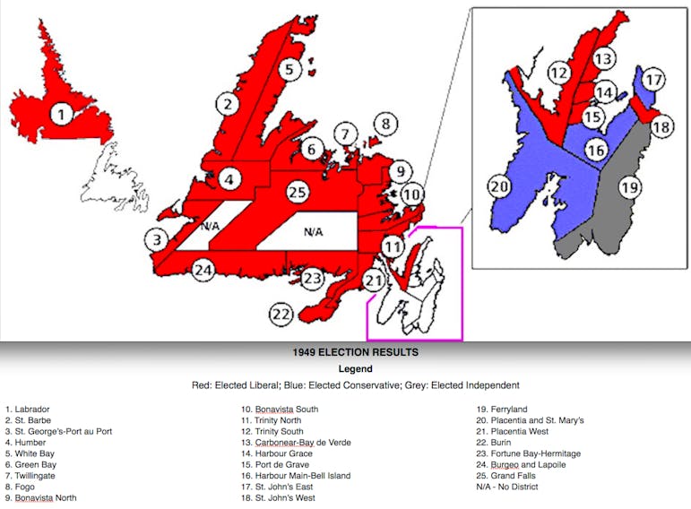
It could be said those initial 25 were simple in form — Humber, Twillingate, Fogo, Burin, White Bay, Grand Falls, Green Bay, Labrador, Trinity North, Trinity South, etc. — making their locations fairly easy to identify.

Since then, names have had a tendency to become elongated. Three former districts — Grand Falls-Windsor-Green Bay South, Conception Bay East and Bell Island, and the Straits and White Bay North — would be prime examples. Others had many people going to an atlas to look up the included geographic names; Fortune Bay-Cape La Hune, Fogo Island-Cape Freels and Naskaupi might fall into that category.
Some have been almost poetic: the Isles of Notre Dame, encompassing Twillingate and Fogo, or the St. John’s district of Virginia Waters sound more like subjects of sonnets rather than politics. Alas, neither lasted more than two decades.
In contrast, we once had the likes of St. John’s East Extern (now Cape St. Francis), the electoral equivalent of street-naming practices that turn out Main Street Extensions.

Some of the changes have been minor. Two of the original districts from 1949 — Burgeo and LaPoile, and Placentia and St. Mary’s — aren’t much different, name-wise, today, with “and” replaced by hyphens/dashes to produce Burgeo-Lapoile and Placentia-St. Mary’s.
Others have been more substantial. The provincial capital had but two districts in 1949 — St. John’s East and St. John’s West — covering the entire Northeast Avalon. Today, there are 13 in the same area.
It must be noted each St. John’s riding elected two MHAs in 1949 and 1952 (so did Harbour Main-Bell Island/Harbour Main until 1975), but even with the double representation, it was argued the two districts in the capital were being short-changed.
After all, in the 1949 election, there were almost 16,000 total votes cast in St. John’s West and about 13,000 in St. John’s East, three to four times as many than in most other electoral districts. There were about 4,800 voters in Bonavista North, 4,400 in Burin, 5,400 in Carbonear-Bay de Verde, 3,300 in Green Bay, 2,300 in Harbour Grace, 2,800 in St. Barbe, 3,400 in Twillingate and 4,400 in White Bay.

There probably wasn’t much political incentive for Joey Smallwood, the province’s first and longtime premier, to change the imbalance and adhere to the principle of “rep by pop” — representation that reflects population. After all, St. John’s was the stronghold of the opposition Tories, while it was rural Newfoundland that had almost unanimously supported Smallwood in both the referendum on Confederation and in the first provincial election.
Nevertheless, things did change over the ensuing years, especially as resettlement greatly reduced the number of rural communities, then as more of rural Newfoundland later emptied with the collapse of the cod fishery.
Larger urban centres like Corner Brook, Gander, Conception Bay South and Mount Pearl, none of which were part of district names in 1949, were eventually designated for a district or districts. Labrador, which had a single district (and later election date) in 1949, came to have four.
St. John’s had five single-member districts in 1956 and, by 1996, there were no less than 14 in the metro area. Mind you, that was when there 52 electoral districts.
Those 52 were eventually boiled down to the present 40; that reduction was the core of the mandate given to the 2015 Electoral Boundary Commission, whose final report — as would be expected — resulted in much border-shifting and associated name changes.

It was complicated work based on a fairly simple formula.
The population of the island portion of the province, using the 2011 federal census, was divided by 36, the number of electoral districts proposed for the island. That resulted in a quotient number of 13,550. The commission was then asked to come up with 36 districts whose populations came as close as possible to that 13,550, although a deviation of 10 per cent more or 10 per cent less was permitted.
The four districts in Labrador, whose total population at the time was 27,000, were not subject to the quotient numbers. That meant two districts in the Big Land — Torngat Mountains and Cartwright-L’Anse au Clair — were maintained in deference to the geographic size of both and the fact each has widely scattered communities, with a scarcity of connecting roads (in the case of Torngat Mountains, none at all).
Exceptions were also allowed in decisions about island ridings. The commission was told it could propose up to two districts on the island that would have a population of more than 25 per cent more or 25 per cent less than the quotient. Special considerations included the common interests of communities not connected by roads, the accessibility of a region, its size or its shape.
Those exceptions were used in the designation of the south-coast districts of Fortune Bay-Cape La Hune (2011 population: 7,373) and Burgeo-LaPoile (8,993), each including areas that could be described as remote, either in terms of distance by road to major centres or because of the absence of roads altogether, with ferry service being the main connector.

Otherwise, the commission managed to stay within the mandated ranges, although some geopolitical gymnastics were required in some instances.
Take the long, thin district of St. George’s-Humber (originally proposed as St. George’s-Grand Lake). Near its northern end is the town of Pasadena, which traditionally has had more in common with Corner Brook and Deer Lake, each 15 minutes away, but each in a different electoral district.
Instead, to satisfy population requirements, the commission came up with a district that included parts of three previous districts and stretches from Pynn’s Brook, outside Deer Lake, for about 220 kilometres along the Trans-Canada Highway, all the way to Tompkins, near Port aux Basques (part of Burgeo-LaPoile), and taking in Stephenville Crossing and Black Duck Siding, both minutes away from the town of Stephenville, which is in yet another district (Stephenville-Port au Port).
There were those who felt the commission’s recommendations still left metro St. John’s with less representation than was warranted, noting 12 of the 13 proposed districts in metro had populations above the quotient (Cape St. Francis was the exception).
Given increased urbanization, that population balance is almost certainly tilted even more toward St. John’s and environs today. But that will be the consideration — or headache — of the next Elections Boundary Commission, scheduled to be formed in 2026.
What will result from that work five years from now, we can’t say for sure. Name-calling during contentious hearings? Possibly. But it’s almost a certainty there will be more name-changing when it comes to districts.
Note: cutline of Smallwood photo has been edited to show Ed Roberts was the Liberal leader in the 1972 election
HOW DISTRICTS HAVE CHANGED OVER THE YEARS
The 25 districts for the 1949 Newfoundland election, the first in the province’s history, with the current districts that now encompass the original ones (or at least a large part of the original district). As well, there are listed some of the other names attached to those districts (or again, to significant parts of those districts) over the years:
• Bonavista North
Today: Fogo Island-Cape Freels and Bonavista
• Bonavista South
Today: Bonavista
• Burgeo and Lapoile
Today: Burgeo-Lapoile
Formerly: Burgeo-Bay d'Espoir, Lapoile
• Burin
Today: Burin-Grand Bank
Formerly: Grand Bank
• Carbonear-Bay de Verde
Today: Carbonear-Trinity-Bay de Verde
Formerly: Carbonear, Carbonear-Harbour Grace
• Ferryland
Today: Ferryland
• Fogo
Today: Lewisporte-Twillingate and Fogo Island-Cape Freels
Formerly: Lewisporte, Twillingate-Fogo
• Fortune Bay and Hermitage
Today: Fortune Bay-Cape La Hune
Formerly: Fortune, Fortune Bay, Hermitage, Fortune-Hermitage
• Grand Falls
Today: Grand Falls-Windsor-Buchans
Formerly: Windsor-Buchans, Windsor-Springdale, Grand Falls-Buchans, Grand Falls-Windsor-Green Bay South
• Green Bay
Today: Baie Verte-Green Bay
Formerly: Baie Verte-Springdale, Baie Verte, Baie Verte-White Bay
• Harbour Grace
Today: Carbonear-Trinity-Bay de Verde
Formerly: Carbonear-Harbour Grace
• Harbour Main-Bell Island
Today: Harbour Main and Conception Bay East-Bell Island
Formerly: Bell Island, Harbour Main, Harbour Main-Whitbourne, Mount Scio-Bell Island
• Humber
Today: Corner Brook
Formerly: Humber East, Humber West
• Labrador
Today: Lake Melville, Torngat Mountains, Labrador West and Cartwright-L'Anse au Clair
Formerly: Labrador North, Labrador South, Eagle River, Menihek, Naskaupi
• Placentia and St. Mary's
Today: Placentia-St. Mary’s
Formerly: Placentia East, St. Mary’s, St. Mary’s-The Capes
• Placentia West
Today: Placentia West-Bellevue
Formerly: Placentia, Bellevue, Burin-Placentia West
• Port de Grave
Today: Harbour Grace-Port de Grave
• St. Barbe
Today: St. Barbe-L'Anse aux Meadows
Formerly: St. Barbe North, St. Barbe South, Strait of Belle Isle, The Straits-White Bay North
• St. Georges-Port-au-Port
Today: Stephenville-Port au Port
Formerly: Port au Port, St. George’s, Stephenville, St. George’s-Stephenville East
• St. John’s East
Today: St. John’s East-Quidi Vidi
Formerly: Original district included parts of many other former (and current) St. John’s metro ridings, including Signal Hill-Quidi Vidi
• St. John’s West
Today: St. John’s West (although district boundaries are much-changed)
• Trinity West
Today: Terra Nova and Bonavista
Formerly: Trinity North
• Trinity South
Today: Carbonear-Trinity-Bay de Verde
Formerly: Trinity-Bay de Verde
• Twillingate
Today: Lewisporte-Twillingate
Formerly: Lewisporte, Twillingate-Fogo, Isles of Notre Dame
• White Bay
Today: St. Barbe-L'Anse aux Meadows
Formerly: White Bay North, White Bay South, Baie Verte-White Bay, The Straits-White Bay North
Current Districts not listed above (with dates of creation)
• Cape St. Francis (1996)
Formerly: St. John's East Extern, St. John’s East
• Conception Bay South (1975)
Formerly: St. John’s North, Harbour Main
• Exploits (1975)
• Gander (1956)
• Humber-Bay Islands (2015)
Formerly: Bay of Islands, Humber West
• Humber-Gros Morne (2015)
Formerly: Humber Valley, St. Barbe
• Mount Pearl North (2006)
Formerly: Waterford Valley, Waterford-Kenmount, Mount Pearl
• Mount Pearl-Southlands (2015)
Formerly: Mount Pearl South, Mount Pearl
• Mount Scio (2015)
Formerly: St. John’s North, Bell Island-Mount Scio
• St. George’s-Humber (2015)
• St. John’s Centre (1956)
• Topsail-Paradise (2015)
Formerly: Topsail
• Virginia Waters-Pleasantville (2015)
Formerly: Virginia Waters, Pleasantville
• Waterford Valley (2015)
Formerly: Kilbride, St. John’s South
• Windsor Lake (2015)