By now you surely know that I love it when people are curious about the weather. Earlier this week, self-proclaimed weather nerd Kathleen MacEachern tweeted: “I quite like a good thunderstorm, but Halifax doesn't seem to get many... is there a scientific reason for that or is it just luck?”
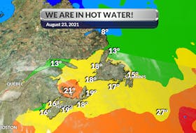
Very good observation and great question, Kathleen. If you travel around in the summer, you’ve no doubt come across some amazing thunderstorms away from our beloved coastlines. Central New Brunswick is a hot bed for wild, late-afternoon thunderstorms in the summer. The climate there is continental: lots of land that warms up quickly. Halifax, like many other Maritimes communities, sits at the coast and enjoys a maritime climate accentuated by cooling temperatures coming off the water - there lies the answer.
In order for a thunderstorm to develop you need two things: moisture and rapidly rising warm air, also known as convection. There is less convection at the coast in part due to the cool water temperatures off shore. Those cool waters impact the temperature of the air that moves inland, making it generally more stable and less convective. This more stable layer of air is called a "marine layer" and it is not conducive to thunderstorm growth.
- Read more Weather University columns.
- Have a weather question, photo or drawing to share with Cindy Day? Email [email protected]
Cindy Day is the chief meteorologist for SaltWire Network.